Project OspreyTrack: Saco Map
November 1, 2011
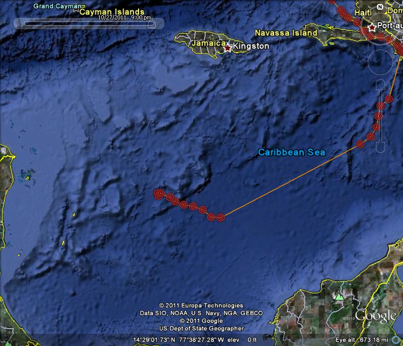
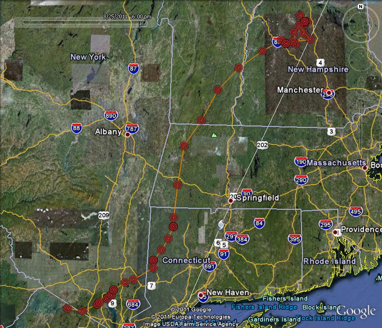
My worst fears are realized. There have been no more updates from Saco's transmitter, so we can now be sure that she ditched in the Caribbean and died. A tragic, but probably all too common fate for young Ospreys. Looking at the weather data shows that she flew into terrible weather sweeping west through the Caribbean Sea (see radar shot below). The storms pushed her off course and hundreds of miles from land and after 30+ hours and 600 miles of flying, she dropped exhausted into the sea. It has been a very tough 10 day stretch for the tracked Ospreys. Three of the other seven Ospreys were lost. To see the sad details of Rob's other birds go to http://www.bioweb.uncc.edu/bierregaard/migration11.htm Right from the start of this project, I have known that only 50% of young Ospreys survive their first migration, and at each step of Saco's epic journey I have braced myself for disaster to befall her. Having watched her via webcam since the first day she emerged from an egg last June, having held her in my hands; felt her heart beating; looked into her eyes, having watched her take her first flights, and now after vicariously migrating with her for more than 3,600 miles over the last two months, her loss gut wrenching. In a text message I received from Rob, he summed up our feelings well: "Someone needs to tell mother nature that we don't need any more teachable moments about the danger of fall migration."
October 29
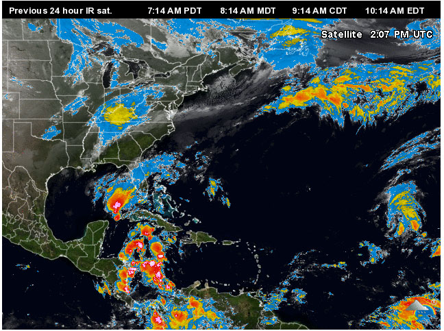
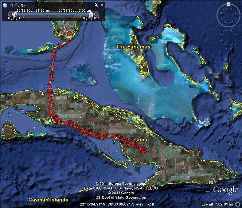
Saco is in trouble. Her last position is hundreds of miles out in the Caribbean and possibly on a ship heading in the wrong direction! After reaching Ile de la Gonave on the evening of the 24th, she spent the night close to the north edge of the island. By 10am on the 25th she was well on her way heading east-south-east. By noon she had reached the main island of Haiti and was 20 miles west of Port-au-Prince. She ended the day roosting near Oviedo on the southern most tip of Haiti about 140 miles from her previous night's stop. I'm missing a bunch of points for the early part of the 26th, but by 2 pm she was more than 100 miles to the south out over the Caribbean. By 7pm she was another hundred miles to the south-south-west about half way to Venezuela. Then she started veering south-west rather than south. There is another gap in data, but she kept flying and by 10am on the 27th she was 308 miles from the 7 pm point (!) still out over the middle of the Caribbean Sea. By 11am she had slowed down and was heading west (wrong direction) further away from South America. By noon she was heading north-west. She was still over a 1000 feet up and moving at 28kph. By 5pm she was still moving west still more than 300 feet up and going at 27kph, but made a course correction and started heading south-west again but her speed and altitude were dropping. At 6pm, having flown continuously for more than 30 hours and covering 640 miles non-stop, she suddenly slowed to a crawl and her next hourly point was just 2 miles to the north (!). Her next two points were over a span of just 3 miles, drifting north; the last point being at 9pm on 28th. She was about as far from land as she could possibly be (300 miles of open ocean in all directions!!). Rob thinks she hitched a ride on a north-bound ship for the last three hours of data (which is the best case scenario) but I fear she might be down and floating in the water. Now I have to wait for three days for another update, but I fear the worst.
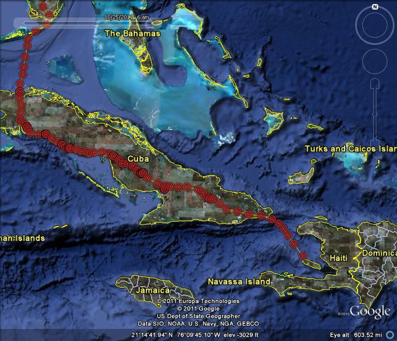
October 25 SACO IS IN HAITI
She spent the night of the 19th near those lakes near El Jobo. She spent all the next two days there too -- must have been good fishing, or perhaps the northern edge of hurricane Rina kept her grounded. She's on her way again between noon and 1 p.m. on the 22nd and headed east-south-east less than 50 miles before stopping for the night south-east of Ramirez. By 9 a.m. on the 23rd she was 3 miles to the north of her roost over a small wetland (breakfast?). She continued for a short way on a north-east route and then was heading east again. She logged another 91 miles at a good pace and at times over 3,000 feet up. She ended the day just east of Biran near Parque Nacional la Mensura. By 9 a.m. on the 24th she on her way again and gliding at 3,300 feet up and averaging 30 km/hr and heading east. She left the south-east tip of Cuba somewhere between Rio Seco and Jauco shortly after 3 p.m. and was over open water until 9 p.m. (last location of this download) when she was just seven miles from Ile de la Gonave, an island just off the west coast of Haiti. She was cruising at 27 km/hr and 1,600 feet up and climbing, so would have easily made landfall within the next hour.
October 20
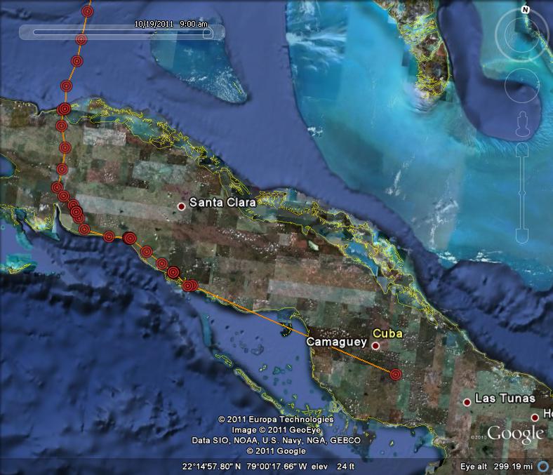
Most recent data download filled in the missing days. She was still present at her previous night's roost site just east of Trinidad at noon on October 16, but by 1pm she was on her way again. At 3pm she had hit the southern coast again at Bahia de San Pedro. She stopped off for a couple hours on an island in a small tidal lagoon, then spent the night on a wooded hilltop a couple miles inland and about 2.5 miles from the town of San Pedro. She was still there at 9am on the 17th but by 10am was heading south-east again looping around some heavily farmed land and paralleling the coast about 2 miles inland. She stopped briefly at 2pm on a wooded ridge in the midst of heavily farmed land, but continued east ending the day about 18 miles west of Florida, Cuba, about 8 miles inland. On the 18th she was on the road by 9am. She passed just south of the city of Camaguey. By 4 pm she had found a nice little lake just east of El Jobo where she did some fishing. She spent the night and the following morning here (about 60 miles from the previous night's roost) and then doubled back by 4 miles to another nice looking lake west of El Jobo where she was fishing at 3pm on the 19th. She's now about 2,485 miles into her journey.
October 19
I got a partial download today with a fresh GPS data point for 9:00am this morning showing that she was near Camaguey. There is a gap of a couple days (which will fill in on the next download), so I don't know her exact route, but clearly she is still steadily making her way east through Cuba. She has traveled about 300 miles since hitting the coast of Cuba late in the day on the 13th.
October 16
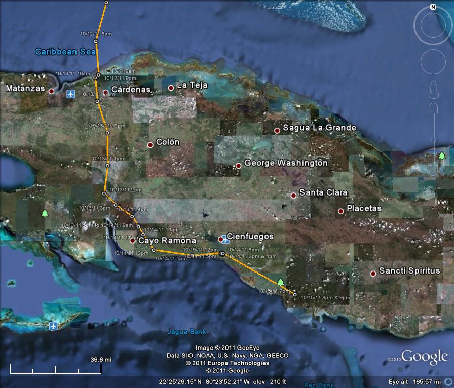
After roosting near Varadero, she was on her way by 10 am on the 13th. By 12pm she was passing Jovellanos and ended the day in a remote swampy area east of El Jiqui (another 73 miles). On the 14th she was on her way by 10am. After passing El Rincon, she jogged east again and hit the southern Cuba coast at 1pm east of Guasasa. She stopped off to fish along the south shore of Behia de Cienfuegos. She spent the night here and was fishing near the same area as yesterday, but was on her was again shortly after noon. By 9pm on the 15th she was just east of Trinidad, Cuba having logged another 35 miles.
October 13
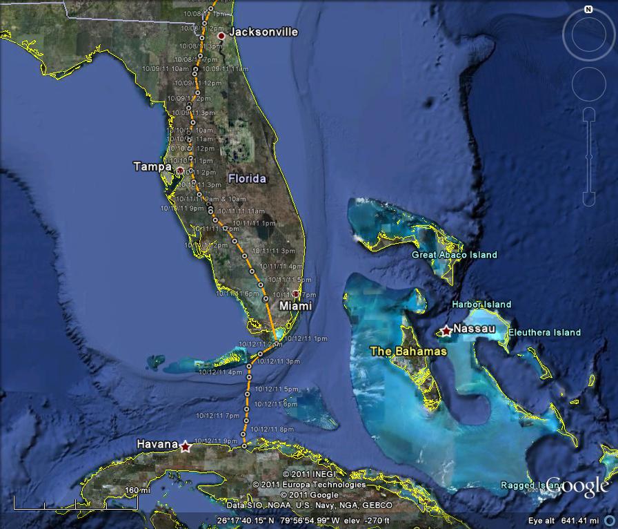
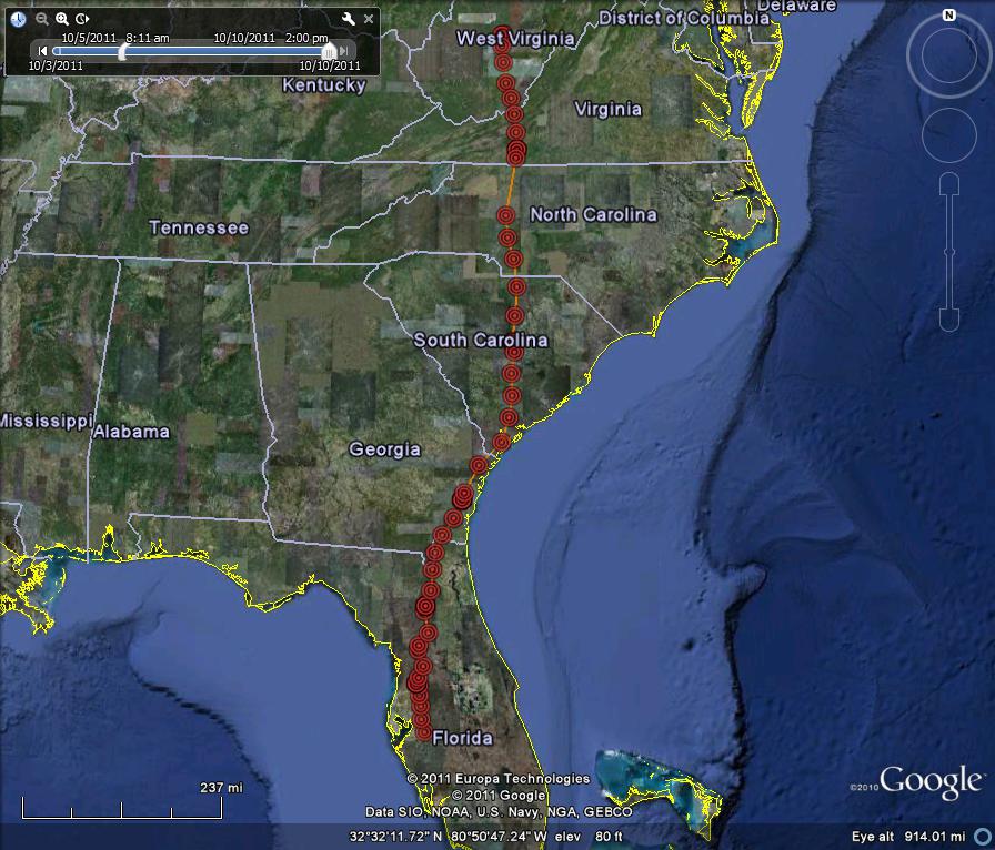
Saco is now safely in Cuba. She continued her southern push through Florida on October 10 ending the day near Peace River (after a little fishing) just north of Arcadia in DeSoto County -- another 90 miles under her belt. On the 11th she pushed on in a more south-easterly route over Labelle and the Big Cypress National Preserve, ending the day in the middle of the Everglades about 35 miles west of Miami (127 miles from her previous night's roost). There is a gap in my data (which will fill in on the next download) and my next point is from 1pm on the 12th when she was 54 miles south near Plantation Key; 13 miles from Key Largo. By 3pm she had started out over the Caribbean Sea just south of Vaca Key and made the 100 mile crossing over to Cuba in 6 hours. She landed near Varadero in a very swanky looking resort area.
October 11
Saco is really on the move. On October 8 she left Georgia and headed south through Florida, ending the day roosting just north of Gainesville, FL (Alachua County). From roost to roost she travelled 120 miles. On the 9th she continued her southward journey, going another 85 miles to end the day roosting next to Rt. 98/50 near Brooksville in Hernando County. On the 10th she was on her way between 9 and 10 am. By 2 pm (last data point in this download) she was just west of Alafia River State Park in Hillsborough County, FL. Straight line distance from Sutton, WV is a little over 750 miles.
October 8
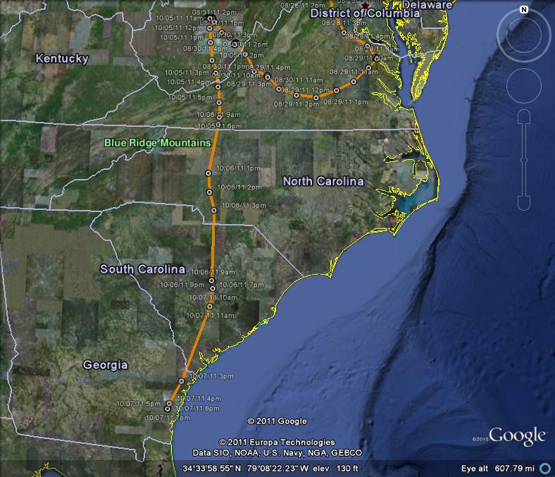
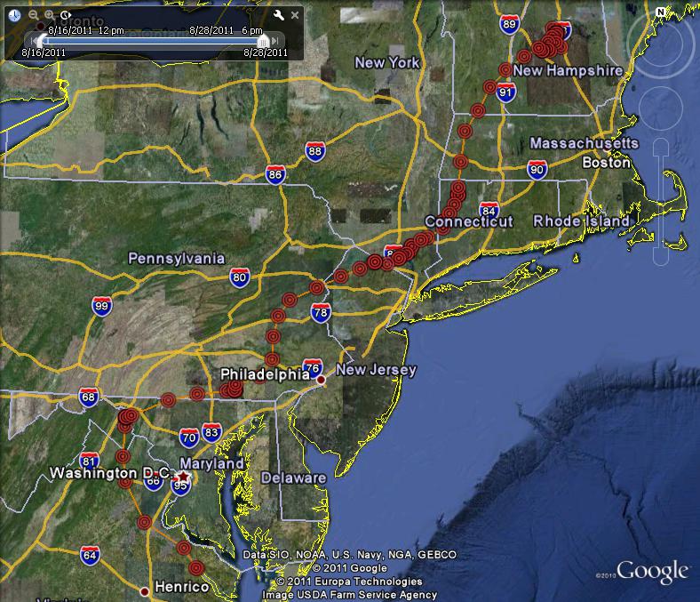
Saco finally decided to leave the Elk River and the town of Sutton and follow the urge to head south. At 11 am on October 5, she was hunting along the river for the last time. By noon she was heading due south and by the end of the day she was 129 miles away in West Virginia. She roosted hear Buffalo Mtn. in southern Floyd County. On the 6th she moved another 207 miles all the way through North Carolina, passing just east of Charlotte. She roosted just south of High Island near Wateree in Sumter County South Carolina. On October 7 she continued south through South Carolina, past Savannah and ended the day roosting along the Altamaha River in McIntosh County in Georgia. Since leaving Elk River she has travelled over 500 miles in two and half days. Her over all, migration route since leaving Ayers Island (excluding most of her month of back forth along the Elk River) is just over 1,500 miles.
September 27
No change. Still on Elk River. Any day now, she'll get the urge to head south and then, she'll really put on the miles.
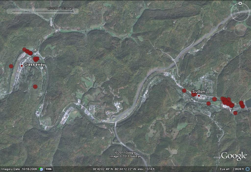
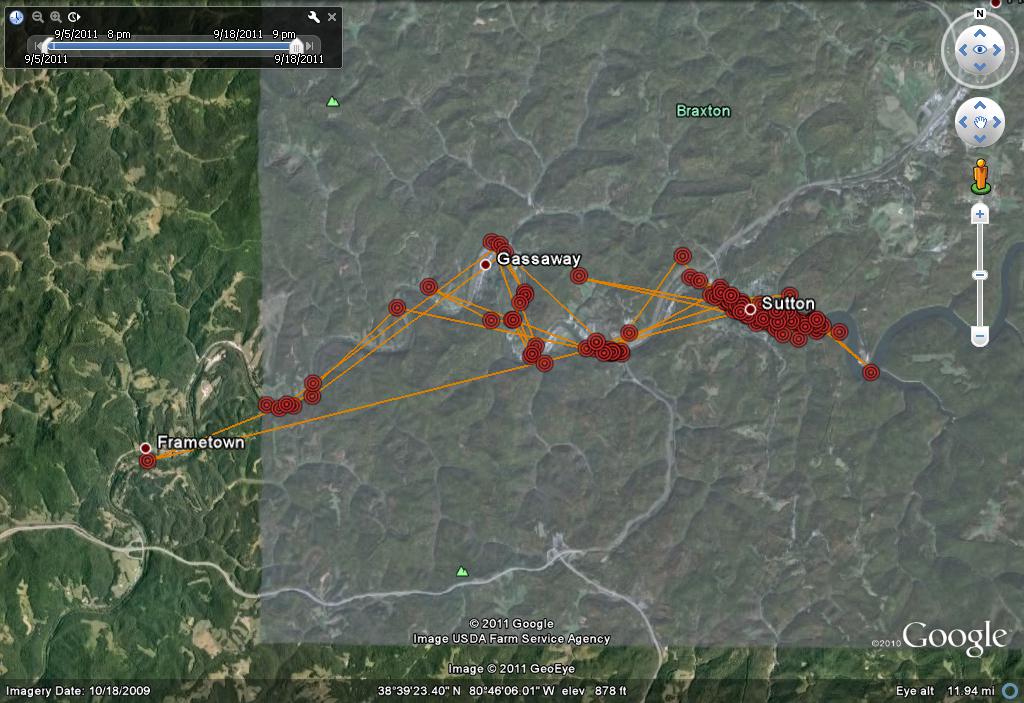
September 23
She is still relaxing along the Elk River in WV. She is spending more time down river at Gassaway but still returning to her favorite haunts in Sutton. This map shows positions for the last four days only. All of the positions on the 22nd were in Gassaway, so maybe she has caught every fish in the river in Sutton!!
When will she resume her migration?
September 20, 2011
Saco is still on the Elk River. She has been exploring a little (up to 8 miles down river from Sutton), but REALLY likes fishing right below the dam. I assume there are lots of fish here and she is perfecting her fishing skills before moving again. She was the first of NE satellite-tagged birds to leave, so she has plenty of time to relax. Below are links to the other birds that Rob Bierregaard is tracking:
Buck:
http://www.bioweb.uncc.edu/bierregaard/maps11/buck2011.htm
Sanford: http://www.bioweb.uncc.edu/bierregaard/maps11/sanford2011.htm#7-30_Apr_2011
Sr. Bones: http://www.bioweb.uncc.edu/bierregaard/maps11/Bones2011.htm#6-30_Apr_2011
North Fork Bob:
http://www.bioweb.uncc.edu/bierregaard/maps11/bob2011.htm#1-30_Apr_2011
Katbird: http://www.bioweb.uncc.edu/bierregaard/maps11/katbird20111.htm
Henrietta:
http://www.bioweb.uncc.edu/bierregaard/maps11/henrietta.htm
Snowy: http://www.bioweb.uncc.edu/bierregaard/maps11/chappy%20ali.htm#11-15_Aug_2011
September 10
Still on Elk River in Sutton. She really likes it here!
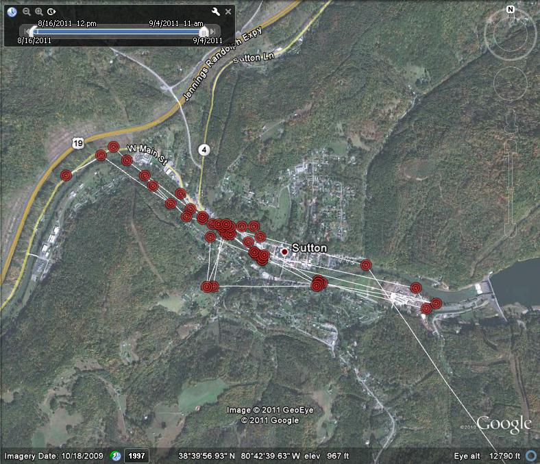
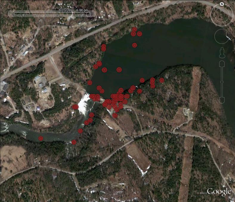
September 7
Saco has settled in for a few days in West Virginia. She was still fishing along the Elk River in Sutton, WV at 6 p.m. on September 6. She has been here for five days. As you can see from the photo she is hunting just below the Sutton Dam.
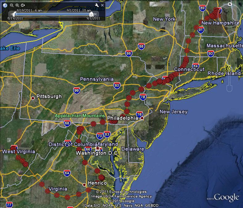
September 4
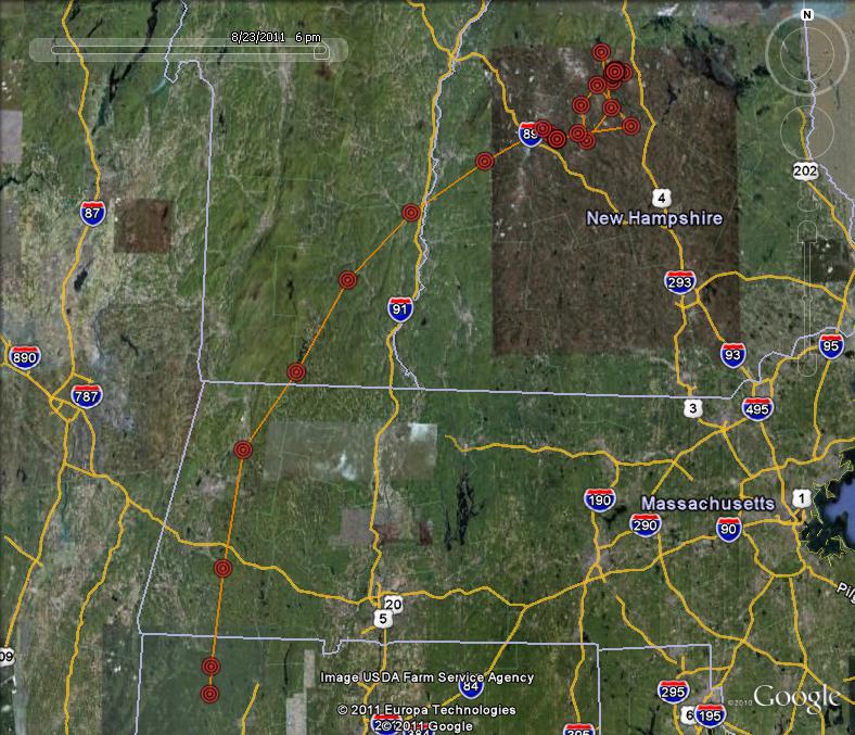
Here is a map showing Saco's roost locations for the first 10 days of her migration. She still has a long way to go. Will she head for Venezuela . . . Colombia . . . Brazil . . .?
September 1, 2011
Here is Saco's migration story so far.
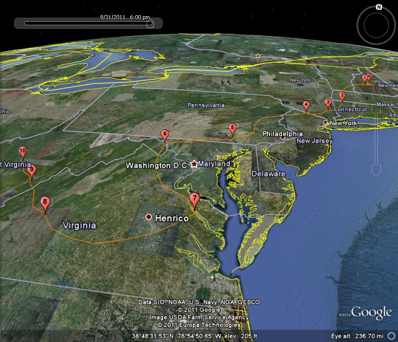
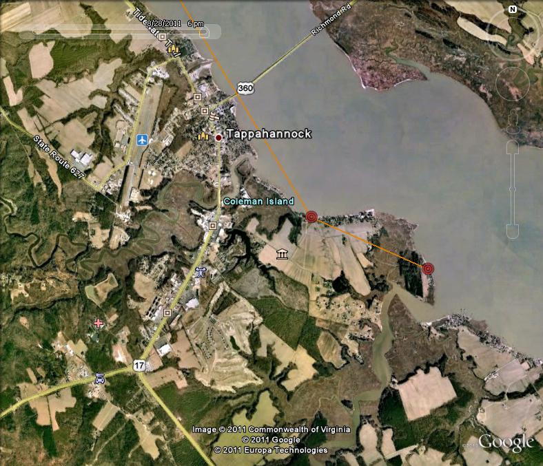
Saco left the nest for the last time on Monday, August 22 at 9:11 a.m. and, after a tour of several nearby fishing locations, she headed west and spent her first night perched on the shore of a small beaver pond just south of Pleasant Lake near New London. The next day, she travelled 135 miles and ended up perched on the edge of another beaver pond near North Canaan in Connecticut. On the 24th, she travelled 55 miles to a hill-top roost site in New York, then by the end of the next day she was 32 miles away in New Jersey. On August 26, as Hurricane Irene swept towards the east coast, Saco made a 150 mile push and ended up spending the night near the Holtwood Dam on the Susquehanna River in Pennsylvania. After fishing on the spillway below the dam (which must have looked a lot like home), she pushed on another 85 miles, spending the night and next morning on the Potomac River near Sharpsburg, Maryland and Tuscarora, West Virginia. On Sunday, August 28, she made another good push, traveling 132 miles to the coast of Virginia, ending the day perched on the edge of the Rappahannock River just south of Tappahannock. She spent the night of the 28th-29th along the Rappahannock around some nice water-side cottages and boat docks. She hung out here until 9:00 a.m. working her way along the tidal edge (fishing) but by 10 a.m. on the 29th she was on the move again and crossing the Mattaponi River near King William. By 4:00 p.m. she was at Big Island along the James River having traveled 168 miles point to point. I am missing data for the 30th, but by 6 a.m. on the 31st, she was 80 miles to the west-north-west on the other side of the George Washington National Forest. From 8-11 a.m. she was fishing along the Greenbrier River near Buckeye in Pocahontas County, WV. By noon she was on the move again by the late afternoon she had reached the Elk River near Sutton in Buxton County, WV (another 109 miles under her belt/wing). She spent the night here and was still fishing here at 10 a.m. on September 1st (today). No surprise, she is hunting just below a large dam. Her point to point total since leaving the nest is about 926 miles.
August 29, 2011
What a good girl. She did a lovely loop around the storm, and by 6 p.m. Sunday she was on the coast of Virginia just south of Tappahannock in Essex County Virginia. Looks like a nice place for an Osprey (see second image). She seems to know what she is doing. At one point on the 26th she was within 11 miles of Hawk Mountain in PA, so she was following a very busy raptor migration corridor.
August 25, 2011
Saco made it to NJ by Thursday evening. At 6 p.m. she was perched next to a nice little wetland surrounded by lots of lakes (nearest lake is Wawayanda) in the Highland Lakes area of Sussex County, NJ. Looks like a nice spot to hang out and ride out a storm. Since leaving Ayers Island on Monday morning, her point to point distance is a little over 280 miles.
August 24, 2011
Saco is on her way! After sticking pretty close to the nest since she fledged on July 23, she got a little more adventurous on Saturday, August 20 travelled several miles from the nest before returning. She left the nest for the last time at 9:15 a.m. on August 22. By 10:00 a.m. she was over Newfound Lake (likely a fishing spot that her father uses). She then made a loop around the western Lakes Region visiting waterways in Andover and then was hunting on the rapids just below Franklin. She took a westward trip over towards New London and spent the night on a small pond near New London. On Tuesday morning there were several data points along the shore of this pond (fishing?) then she headed west again along the shore of Pleasant Lake and took a steady south-west bearing and headed through south-east Vermont, quickly through Massachusetts and by 6 p.m. on Tuesday, August 23 she was perched on the shore of a small wetland in North Goshen in north-west Connecticut about 140 miles from her nest.
August 16, 2011
Saco continues to explore the area around the nest and is ranging further up and now down the river. She is likely following her father as he fishes up stream and downstream and perhaps is learning to fish for her self. Saco and her untagged sibling continue to stop by the nest multiple times each day to take delivery of food from their father. Their mother has not been seen on the nest in the last week (I last saw her on the webcam on August 6) and she may have already started her southbound migration – her work is done for another year.
In addition to Saco, Rob Bierregaard is following several other satellite-tagged Ospreys. To follow their journeys check out the link below: http://www.bioweb.uncc.edu/bierregaard/migration11.htm#The_July-August_
August 2, 2011
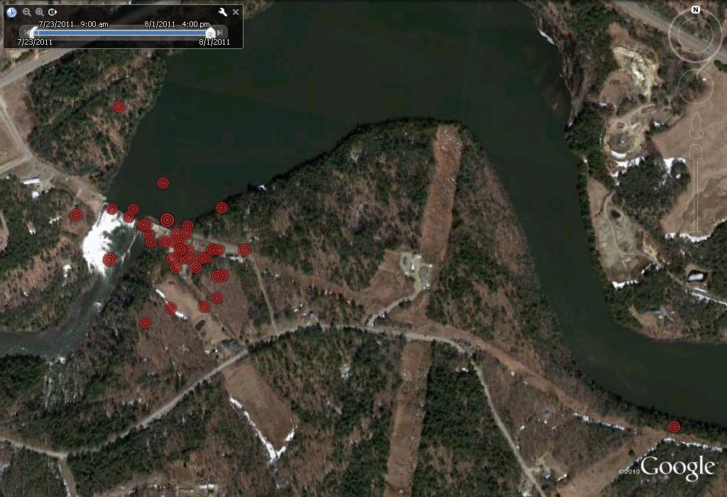
Saco has successfully made her first take-offs and . . . even more importantly . . . landings. She has been exploring the area since an apparent first flight on July 23. This first data point away from the nest surprised us all, as no one watching on the webcam saw her leave or return, but according to the satellite data she was ¾ of a mile away and up river at 9:00 a.m. on the 23rd. Hourly data from the 24th through August 1, shows that she has spent time away from the nest each day and has been perching on the dam, riverside trees and utility poles around the nest. The third (untagged chick) took its first flights on July 29 and has been gaining in confidence over the last four days and spends much time away from the nest. Both return to the nest for feeds.
Tuesday, July 12
After nearly a year of planning, Project OspreyTrack really got underway today. We successfully deployed two GPS transmitters on the two largest chicks at our target nest at the PSNH Ayers Island Dam in New Hampton, NH. Over the coming weeks, months, and maybe years I will post periodic updates with maps showing noteworthy occurrences. It’s going to be eventful.
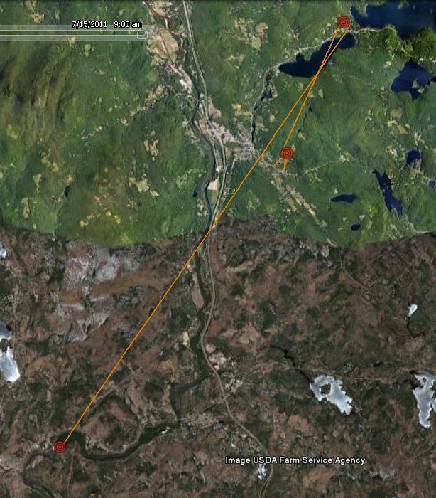
This first map shows the movement of transmitter number 106891 as it travelled from my house in Ashland to the Squam Lakes Natural Science Center to the Ayers Island Dam where it is safely harnessed to Saco in the nest. Saco should be taking her first flights by the end of July.