
Project OspreyTrack: Maps
Get the latest Osprey migration information via Twitter - @OspreyNH
Thanks to Movebank.org, we are now able to present data in an interactive format using the map below. Please be patient as the data points load.
Smart Phone App.: Follow all our Ospreys (and dozens of other species across the globe) on the Animal Tracker (available on iphone and Android). Download for FREE at https://www.movebank.org/node/36241
NEW network links added for each of our newly tagged birds. Follow the directions on the PDF on creating Network Links. You can create a Network Link for each on your own version of Google Earth.
2018 Interactive Osprey Tracking Map:
Click on the individual dots/lines of each bird to see their names and date of most recent point. Zoom in to see their movements in detail. Use the calendar feature to track locations of all birds on specific dates.
Holly (red), Adult female tagged May 2016 on Chesapeake Bay, MD. Winters in eastern Brazil.
Borealis (hot pink), Juvenile female tagged September 12, 2017 in St. John's, Newfoundland. Sister of Aster and Da Rock
March 27, 2018
And now there are two. Only Borealis and Holly are still transmitting. Holly just showed up in Jamaica after four months under cover.
March 7, 2018
Well it’s been a quiet winter with so few birds to monitor. Borealis is the only bird we have had data from all winter and she is doing fine at her winter home in central Florida. She is expected to stay there for the rest of this year and not head north again until spring 2019. Holly hasn’t chimed in since November, but we hope that she is fine and just out of range of cell towers. Last year she started her journey back to Maryland on March 14, so let’s hope that we suddenly get a signal from her in the next couple weeks as she moves her way along the S. American coast.
The only other piece of interesting news over the winter was that a recovery expedition was organized to the remote beach in Colombia in January where Shana’s transmitter continued to send intermittent signals. Her remains were found (just bones) with the transmitter and leg band still attached.
November 14, 2017
Holly finally chimed in from Eastern Brazil! After radio silence for more than a month, she started sending signals again last week. She was back at her winter home on the Rio Piranhas in Itajá on Saturday. Meanwhile Borealis cut across the Georgia Bite (as so many Ospreys do) and flew from Cape Lookout in N. Carolina to southern Georgia. She is now south of Jacksonville, Florida.
November 3, 2017
And then there was ONE!! Shana got back on track and crossed over to Cuba and then across to Haiti and the Dominican Republic. She concerned us for a while when she hung out in DR for a week or so, but then headed across the Caribbean in what looked like lovely clear weather on October 23. When she next uploaded data on the 25th we were horrified to see that she was still over water, moving very slowly and “drifting” off the coast of Colombia. It looks like she landed on a ship for a period of time but then appeared to be floating (dead). She did upload again 3 days later and was still floating offshore. This is another confounding loss – an experienced bird crossing in apparently clear weather. What is going on this year??
We have not heard anything more from Holly, who last chimed in on September 30. She should have reached her winter home in eastern Brazil by now (where we got lots of clear signals from her last winter). We are beginning to think that she didn’t make it.
So that just leaves Borealis who is STILL hanging out in New Haven, CT!! This is very like Leif (a Newfoundland chick from last year) who hung around in Lewiston, ME until November 11. No pressure Borealis, you are the only bird we have left!!
October 5, 2017
The last 2 weeks have been REALLY tough for our Ospreys. In addition to losing Staddler, we also lost Flow, Da Rock, Layla, and Tommy. Flow died on Assateague Island in Virginia. His last signal was on the 23rd. Tommy reached the Sandy River in Maine and then went silent on September 23. Layla reached northern Florida and went silent on September 25. Da Rock hasn’t sent any uploads since September 27 along a remote river in Newfoundland. These last three losses are inexplicable and could be transmitter malfunctions, but we will likely never know.
Holly reached Colombia and went back into radio silence. Hopefully she will get close enough to a cell tower to give us an update soon, but we may not hear from her again until she reaches her reservoir in eastern Brazil.
Shana is making us nervous by hanging out along a busy 4-lane highway in southern Florida, but she checked in today and is doing fine. Borealis is still hanging around the Yale campus in Connecticut. She too logged in today and is busy fishing. So having started off the fall season with 8 active transmitters, we are now down to just three.
September 26, 2017
Things are not looking good for Staddler. His latest points suggest that he is dead and floating off the coast of Venezuela (drifting north-west). He embarked on a lengthy flight across the Caribbean beginning in Cuba at 11am on September 21. He crossed the western tip of Haiti later that day and then continued on through the night out into the Caribbean Sea. My guess is that he hit the outer bands of Hurricane Maria as it skimmed north of Hispaniola. The winds would have pushed him south and east away from the southern coast of Haiti. He flew all that night and the next morning was still only half way across the Caribbean. He then made a strange turn and I think he might have landed on a ship. His remaining points that day were all 10m above sea level and his speed was only between 12-16kph. When he uploaded again yesterday we only got a few points and they were all just offshore from the Venezuelan port of Punto Fijo. The last point was about 35 miles offshore. All indications are that he is dead. Another sat. tagged Osprey from Michigan was crossing the Caribbean at the same time and seemed to take a remarkably similar route. I haven’t seen an update from that bird today (should have uploaded yesterday) so it may have had a similar fate.
Here is a video that shows what Staddler flew into as he crossed the Caribbean. It’s obvious that the outer bands of Hurricane Maria pushed him south of Haiti and once in the Caribbean, he was encountering strong winds and rain. He hit a wall of heavy rain during the middle of the second day of his crossing and I suspect he then landed on a ship for the remainder of his crossing to Venezuela. He either died on the ship or shortly after arriving in Venezuela.
Here's a new version of Staddler's crossing showing his route more clearly...and times. pic.twitter.com/QOGrKeQ8Ww
— OspreyTrack N.H. (@OspreyNH) September 28, 2017
September 22, 2017
Staddler made quick progress to Cuba and has avoided the hurricanes so far. Flow faked us out with his move south on September 9. He just shifted to a new staging spot. After checking out Boston, he moved up to the Danvers River just north of Salem, MA. He found a good fishing spot and was spending a lot of time perching on a large electric pylon in the river. He ACTUALLY started his migration on Tuesday. On Wednesday he passed by Cape May and yesterday was fishing near Chincoteague in Virginia. Layla is still hanging in Ohio and we haven’t heard more from Holly since she entered the Cuba transmission blackout zone. Up in Newfoundland, it’s all action. Rob trapped Da Rock’s sister (named Borealis) and redeployed the transmitter from Daphne. Rob was not able to re-trap Aster. Her transmitter has not uploaded again, but she has been seen and is okay. Da Rock was the first out of the shoot, but after heading due south to the tip of the Avalon Peninsula, he changed his mind and retreated back to shore and is making his way west over land. His sister departed soon after and amazingly a few days later they were within yards of each other on the Magdalen Islands in the Gulf of St. Lawrence. Borealis continued west and is now in New Brunswick. Da Rock doubled back again and went back to western Newfoundland. Shana is on Prince Edward Island and Tommy is in New Brunswick (likely will be in Maine later today).
September 12, 2017
Staddler and Flow both started their fall migrations. Staddler is off to the races. He left on Saturday and by Sunday evening was on the N. Carolina coast. He obviously had a good tailwind off the coast and zipped along off the eastern seaboard. Flow made a more tentative start but moved south into the Boston area on Saturday. Holly left the Florida Keys on September 7 and then went into “radio silence” in Cuba. She is wearing a GSM transmitter that communicates with cell towers and we know that Cuba (which uses a different cell system) is a black hole for GSM birds. Last year, we didn’t heard from her again until she reached her winter home in eastern Brazil, so it may be a while. Hopefully she was on the “good” side of Hurricane Irma and was pushed south and east by the rotational winds. Layla (a newly-tagged juvenile from DC) is still hanging out in Ohio. Up in Newfoundland, Aster’s transmitter died almost immediately. We know she is okay. Tommy and Da Rock are still near their nests. Sadly adult female Daphne stopped moving last week and a search found her remains. She had been predated – likely by a Great Horned Owl. Her transmitter was retrieved and Rob was back in Newfoundland on September 12 (today) to try and redeploy the transmitter at Aster’s nest. With luck, he will re-trap her and replace the dead transmitter.
August 18, 2017
As we gear up for the fall migration, it’s time for a long-overdue update on our birds.
Staddler and his mate successfully raised one chick in their nest in Seabrook Harbor, NH. Their summer was very uneventful (which is good) and Staddler’s habits and activities was very similar to previous years.
Having assumed that we lost Wausau (we lost contact with him in February in Colombia), I was surprised to find him perched near his nest in Groveton in late June. His old mate was also present. Their nesting attempt had failed but they were both still present around the nest. So obviously his transmitter had failed.
Belle successfully returned to her usual stomping grounds in MA, but shortly after arriving her transmitter started to fail (deployed since 2010, so plenty of miles on it). We lost contact with her in June, but have no reason to believe she isn’t doing just fine.
Up in Newfoundland, Shana and Daphne returned to their nests. Shana’s nest has a webcam on it (http://www.newfoundlandpower.com/environment/ospreynestcam.aspx) and she has successfully raised 2 chicks which are just starting to fly. We don’t know how many chicks Daphne has but her data certainly suggests that she has chicks. Rob will be returning to Newfoundland in late August to deploy at least two more transmitters.
Flow has continued to explore the coastal areas of northern Massachusetts, New Hampshire and southern Maine. He has spent a lot of time in Seabrook and Hampton Harbor not too far from Staddler’s nest. They have certainly crossed paths many times. Hopefully next year Flow will find a nest and settle.
Down south Hackett and Holly settled at their nest in Annapolis, MD and Holly began incubation, but Hackett stopped moving in late May and his body was retrieved shortly after. We don’t know what caused his death. Holly abandoned the nest and flew to an inland lake where she fed for a while. She has spent the late summer occasionally visiting the nest.
Nick, returned to Tangier Island in the Chesapeake, but didn’t settle. He wandered about and ended up hanging around a wetland north of Washington but stopped moving and we lost contact. We assume he died.
In late July, Rob tagged a chick at a nest on the Anacostia River in Washington, DC. He named her Layla. She is proving to be very interesting and has headed off for a wander all the way to Ohio.
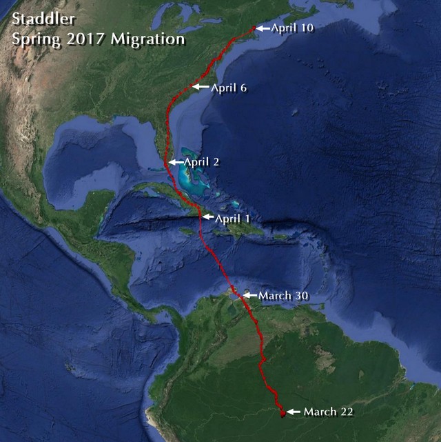
April 12, 2017
Staddler arrived safely at his nest at 3pm on Sunday (April 10). Yesterday he was seen bringing a fish to his mate on the nest. Staddler’s migration took 19 days beginning on March 22. He covered 3,890 miles (6,260 km) and averaged 205 miles per day. His updates this morning indicate that he is right back to his normal routine fishing on Lake Gardner in Amesbury, MA and around Seabrook Harbor.
Meanwhile, Holly has returned to her nest in Annapolis and reunited with Hackett. Belle is doing her usual routine of roaming around the southern Cape and Martha’s Vineyard, but shows no indication of hanging around a nest. Both the Newfoundland females have begun heading north. Daphne is on the Yucatan having left her Panama winter home on April 3. Shana left her Venezuela winter home on April 7 and had reached the northern coast of Venezuela on the 9th. She has likely crossed the Caribbean now. The only bird not to have started back is Massachusetts youngster Flow, who is in no hurry to leave Cuba. Here in New Hampshire, our old friend Art (who we followed in 2012 and 2013) is back at his nest in Bridgewater (we can identify him by his leg band). His old mate (who we banded in 2011) is also back. Gundersen’s old mate (who we banded in 2011) is also back at her nest in New Hampton with her new beau. Donovan’s old mate (who we banded in 2012) is also back at her nest in Tilton with her new mate.
April 3, 2017
Staddler is in Florida. He has really turned on the turbos and made short work of his Caribbean crossing. He flew straight from Venezuela directly to Cuba. He left the Venezuelan coast at first light on March 31 and flew nonstop for a little over 600 miles, arriving on the southern coast of Cuba by 8am on April 1. He kept right on going and zipped through most of Cuba on April 1, finally taking a rest to roost and feed near a lake near the north coast of Cuba. He was off the next morning by 9am and by 5pm was in the Florida Keys and by 6pm was at the southern edge of the Everglades. That’s a straight line shot of 1,062 miles in three days. Meanwhile, Belle arrived home in Falmouth on the early afternoon of March 30. She is right back to her usual routine. Nick arrived home on April 1 and Hackett got home on April 2. As Hackett’s data has uploaded, it turns out that he actually wintered in Venezuela. It’s amazing that he eluded a cell tower in that area for the entire winter. Holly popped up again in southern Florida on March 31, and is making her way steadily north. Her mate Hackett will have the nest all nicely spruced up by the time she gets home later this week.
March 28, 2017
Lots to update.
Staddler started his migration on March 22 and is making quick progress. He crossed the Equator on the 24th, crossed into SE Colombia on 26th and into Venezuela later that day. He stopped off on the Orinoco River for a snack or two and was off again on the 27th. Latest data on 28th indicates that he is making good progress towards the Caribbean coast.
Belle is zipping along and as of yesterday (27th) was in North Carolina. Nick vanished once he hit the Caribbean coast and is likely in Cuba (where his cell-tower transmitter doesn’t transmit). He should pop up again once he reaches Florida. Holly is also in a cell-tower black hole and any day now she should reappear when she hits Florida. Her mate Hackett had been offline since September! He popped up yesterday in Florida on his way north and, as suspected, had been in Cuba all winter. It will be great to see this pair race back to their nest in Annapolis.
Flow, Shanawdithit and Daphne have yet to make a move . . . but will any day now. The first report of an Osprey in NH came in over the weekend and pairs are back at nests in CT.
March 16, 2017
Holly is next out of the gate in the great race north. She started on the 14th from her lake in FAR eastern Brazil. Fingers crossed that her mate Hackett shows up again from wherever he has spent the winter. Staddler is still at his winter home. Last year he started on the 18th, so he should be on his way any day!!
March 10, 2017
Belle has started “her” sixth north-bound migration. She headed out on March 6 and yesterday passed through Staddler’s hood on the way north. Last year “she” started on March 4, so “she” is right on schedule. I wonder if this will be the year when “she” finds Mr. Right . . . or Mrs. Right . . . there is some speculation about whether Belle is actually “Beau.” Last summer a photographer got a great photo of an Osprey with a transmitter in the area where Belle hangs out on Cape Cod. Belle’s date indicated that (s)he was in that area at the time. No other active transmitter-carrying birds were known to be in that area. The plumage of the bird in the photo indicates that it is almost certainly a male. So . . . the question is . . . was it Belle, if so then Belle is a male . . . or it may have been one of Rob’s bird still carrying a dead transmitter. If only Belle would settle at a nest, then we could confirm – maybe this year.
March 7, 2017
Well, Staddler fooled us. His three non-GPS points on March 2 sure looked like he was headed north, but . . . no . . . he’s still at his winter home. No award for him . . . we’ll give it to Moonlight instead!!
March 1, 2017
I have good news and bad news. First the bad news. It looks like we lost contact with Wausau. After never missing an upload since his transmitter was deployed in May 2015, we have not heard from Wausau since February 23. He should have sent new data on the 26th and today, but . . . nothing. All of his points on the 23rd were normal with no sign of anything strange, so this may remain one of those unsolved mysteries. I’ll certainly check his nest in April just in case he returns with a dead transmitters, but my guess is that some fatal event happened.
The good news is that Staddler began his northbound migration this morning. He has been sending uploads overnights and into this morning and his last three points indicate that he is moving north well outside his usual winter range. This is more than two weeks earlier than last year and he gets the “first out of the gate” award for spring 2017 (of our tagged birds)
February 16, 2017
Winter is flying by and our first birds should be starting back home in about a month. Wausau has had a very uneventful winter, but Staddler has recently started venturing further afield. He still returns to his little beach on the Tefe but, unlike last year, he has been flying across the Amazon to various backwaters and smaller rivers. Why is a mystery. Belle, Flow, Shana, Daphne and Nick have had a quite couple of months. The sad news is that we lost Leif. He remained in the Dominican Republic but stopped moving on January 14. We suspect he was shot.
December 7, 2016
Leif made rapid progress through Florida. His crossing over to Cuba was weird and we suspect he spent some of the time on a boat as his speed was way too slow for normal flight! He quickly traversed Cuba and then crossed to Haiti and found the classic adult launching point known as Cabo Beata on the southern shore of the Dominican Republic, but he got cold feet and turned around and headed back inland to a lake where he has been since (more than a week). This is worrying. Rob has never had any of his tagged birds successfully winter in Haiti or D.R. One bird that tried was shot at the lake where Leif is hanging out…. so we hope he gets going again and heads over to South America.
Everybody else is very boring and is settled in their winter homes (boring is GOOD)
November 17, 2016
Belle made it back to her winter home on October 27 and is back into her normal winter routine. Shana got to her winter home just north of the Orinoco River on the 28th. She is close to where Donovan’s winter home was. So that just left laggard Leif, who as of last week was still in Maine. Well, he finally got the bug to move south and boy did he ever. He left the Lewiston, ME area at 10 am on the 11th and didn’t stop until he arrived at Daytona Beach in Florida late the next day. That’s 1255 miles (2020 km) in 36 hours of continuous flight. His average speed was 35 mph/56kph, which is really fast. On the 15th he was making his way south through central Florida. These birds never cease to amaze.
October 25, 2016
Staddler, Wausau, Flow and Nick are all settled in. Daphne looks like she is now at her winter home on the Pacific coast of Panama. Shana is loitering in D.R. (which always makes us nervous – not a good place to settle). Holly moved even further east and looks like she is now home on the Rio Piranhas. Belle has reached the Amazon (not too far from Staddler) and should be back at her winter home in another few days. Meanwhile Leif is STILL in Maine. The first snowflakes are flying and it’s time for him to get going again. Virginia’s remains were recovered (along with the transmitter) at the Tom Yawkey Wildlife Center on the South Carolina coast (right where she made landfall). The staff there confirm that the eyewall of the Hurricane hit that area really hard. Rob is planning another trip to Newfoundland next summer to reuse Virginia and Jocelyn transmitters.
October 13, 2016
Staddler is safely back at his winter home on the Rio Tefe next to the Amazon in Brazil. Flow also made it back to his winter home in Cuba. Belle left the Dominican Republic and crossed to Colombia and now is in Venezuela. Holly surprised us and popped up on the Rio Jaguaribe in the State of Ceara in far eastern Brazil. Rob has never had one of his tagged birds go that far east. We had last heard from her in D.R. several weeks ago. Holly is wearing a cell tower PTT, so she had gone quite a while without contacting a cell tower. Nick (another cell tower bird) popped up in Northern Colombia and is close to his winter home.
October 8, 2016
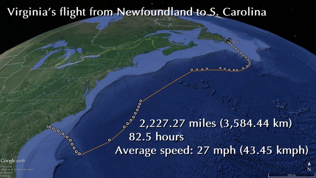
INCREDIBLE!! Virginia arrived on the South Carolina coast late on Friday after flying 82.5 hours nonstop from the Avalon Peninsula in Newfoundland. She flew at least 2,227 miles (3,584 km) continuously which is a new record for a tagged Osprey. Virginia proved that it is possible for an Osprey in Newfoundland to reach the Lesser Antilles or other Caribbean islands in one epic ocean crossing (the straight shot for that journey is 2,100 miles). We believe this makes it the longest documented over-water crossing of any raptor in the world. The previous longest documented migration is by the Amur Falcon which flies from India to Africa across the Arabian Sea (about 2,800 km). Virginia averaged an impressive 43 km/h (27 mph). She landed right in the path of Hurricane Matthew, so her first migration is proving to be a very challenging one. Her mother Shana is now not too far ahead of her in Florida.
October 7, 2016
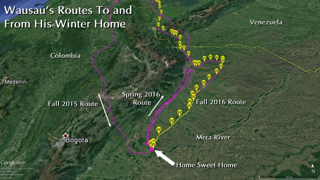
Wausau arrived back at his winter home just north of the Meta River in the Casanare region of Colombia on Wednesday afternoon, 31 days after he departed from his nest in Groveton. Last year he didn’t arrive here until October 21. Hopefully his small lake and fishing holes are as he left them last March and he will settle in for a quiet five months. Staddler pushed south too leaving the coast of Venezuela behind. He has a lot further to go than Wausau and still has at least a week of travel before he reaches the Amazon. Belle checked in from Haiti late last night (more data to come today) so we assume she avoided the worst of the terrible hurricane devastation. Hopefully she won’t linger here and will keep pushing on and cross the Caribbean Sea. Flow checked in from Cuba late yesterday so he is nearly home.
October 6, 2016
Every bird is now on the move. Staddler and Wausau both crossed over to South America. Wausau’s last update showed he was less than 200 miles from his winter home in Colombia (he may be there now). Staddler has headed for a nice looking lake near the coast of Venezuela rather than head straight to his winter home next to the Amazon in Brazil. I suspect he’ll fatten up for a few days then head south again.
Belle is in eastern Cuba. I suspect she hunkered down during the hurricane and will quickly cross to Haiti. Daphne is in Cuba and Nick and Flow are in Florida. Flow did a little over-water crossing of a portion of the Georgia Bight, but was really just “cutting off the corner.” Shana was in Georgia on her last upload (now likely in Florida too), although perhaps all these birds will be stalled by the hurricane. Hopefully they all hunkered down and rode it out.
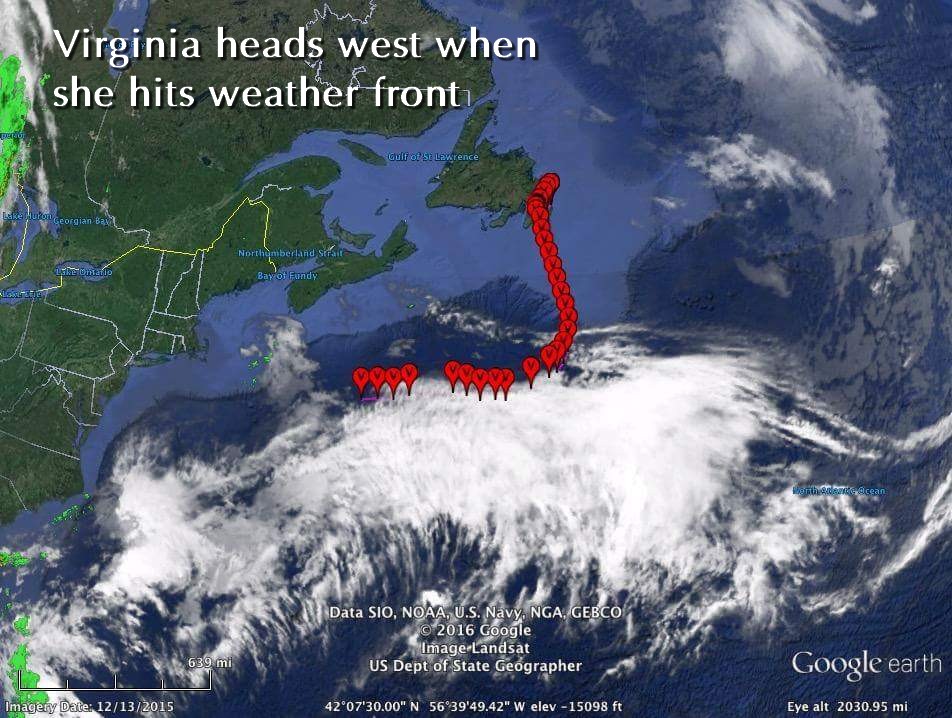
Leif is still enjoying the Androscoggin in Lewiston, Maine and Virginia left the southern tip Newfoundland shortly after 7am on October 4. She headed due south for the whole day, but started banking right (west) by the end of the day. She kept going through the night and by the next morning was headed due west. Her last point of this update (at 6 pm on October 5) showed that she was still flying strongly and had covered 1,400 km (875 miles) and still had at least 700-1,000 km to go until she hits dry land. A look at the weather over the Atlantic reveals that she hit a major weather front and turned to fly along its north edge (smart bird), so that explains the sharp westward turn.
September 30, 2016
STOP Press: New life for Weber. While compiling data for an article on the Osprey project yesterday, I downloaded data for all 16 of the NH Ospreys we have tagged and followed since we started the project in 2011. One of those birds—Weber—was a juvenile that we tagged at a nest in Seabrook Harbor in 2013. Weber mysteriously vanished in northern Venezuela in October 2013 and we assumed he died. His transmitter came back to life briefly in June of 2014 and uploaded some points from the exact same spot and we assumed that the transmitter had just gotten enough sun to upload. It was just a few points from the exact same spot he vanished in and we thought no more about it. It turns out that unbeknown to me his transmitter had continued to send intermittent uploads throughout the rest of the year right up to December and some of the points clearly show that the transmitter was moving around up to a mile from the location we thought Weber had died. So . . . our conclusion is that Weber did not die in October 2013, he had a faulty transmitter and was seemingly still alive in December of 2014. We have no reason to believe that he isn’t still alive now.
Staddler and Wausau were both in the Dominican Republic on Sept. 28 and about to cross the Caribbean. I suspect that their next uploads tomorrow will show them in S. America. Belle started her migration on the 21st and is now in southern Florida. It looks like Nick started on the 29th, but Flow is still at home hanging on the Merrimack River in Lawrence, Ma. Newfoundland adults Shana and Daphne are making good progress down the mid-Atlantic. We lost another of the NF juveniles, Jocelyn was picked up dead with a head trauma in St. John and we have not heard anything further from Trepassey. Leif gave us a scare when he missed an upload right after reaching Maine, but yesterday he popped up again on the Androscoggin River near Lewiston, ME. Virginia is the last NF youngster left up north and is still close to where she was tagged. Our map shows the broad spread of Osprey migration timings with some already in S. America and one still in Newfoundland.
September 19, 2016
Lots going on with our Ospreys. Holly (brick red) popped up briefly in the Dominican Republic (having passed through the dark hole of Cuba) but promptly vanished again (presumably having crossed to S. America). We may not hear from her again until spring. Hackett has not popped up yet. If he winters in Cuba, we won’t hear from him either until spring. Both Staddler (white) and Wausua (light blue) are in Southern Florida. They are both following the classic Osprey highway, as we would expect from experienced birds. Interestingly Wausau passed right over the famous Hawk Mountain hawk watch site on Sept. 5 and must certainly have been counted. His track reveals that he also passed right over three other hawk count sites (Little Gap, Bake Oven Knob and Raccoon Ridge) I wonder if they counted him too? Staddler also wanted to be part of the fall hawkwatch data gathering. He flew directly over the Cape May Bird Observatory and the Cape Henlopen on September 6. He was in good company as 169 Ospreys were counted at Cape May and 145 at Henlopen. Newfoundland bird Daphne (orange) also passed over Cape May on September 12 . . . and then turned around and has been settled near the observatory for at least three days.
Up in Newfoundland, Leif (pale green) started his first migration on Sept. 15. He headed out over open water south of the Avalon Peninsula on the 16th and flew through the night. He looked like he might land on tiny Sable Island, but made a right turn and made landfall on Nova Scotia. Adult female Shana (green) started her migration on the 16th – after a couple false starts – and was making the safer overland path. We suspect that we might have lost Trepassey. He has not uploaded since Sept. 11 – missing two scheduled uploads. That is never good news. We had a ray of hope when a local birder sent Rob a photograph of a young Osprey with a transmitter flying near where Trepassey should be, but we now assume that that was Leif passing through.
September 8, 2016
Both our NH Ospreys are on their way. Wausau (light blue) left on 4th, Staddler (white) left on 5th. Both making good progress along the Osprey flyway. Good luck boys.
September 6, 2016
Three birds are on the move. Holly and Hackett are both in the Everglades (actually by now, Hackett may be in Cuba). Once in Cuba, they will vanish for a while (see below). Daphne, one of the Newfoundland adult females began her migration September 2. As we expected, she did the smart, safe route over to Nova Scotia and then over to Maine, staying over land as much as possible. She will likely pass through the NH coast today – maybe she’ll say hello to Staddler and Flow on the way by. The rest of the Newfoundland pack are exploring more. Who will be the next to head south?
August 31, 2016
Our two New Hampshire adult males (Staddler and Wausau) are still hanging around their territories. My colleague Rob Bierregaard tagged several new Ospreys this year including six birds in Newfoundland. This is an exciting new initiative in the Osprey tracking project. No one has tagged Ospreys in Newfoundland before. This is the most easterly breeding location of Ospreys on North America and we suspect that the juveniles may attempt to fly directly south from here and perhaps have to cross several thousand miles of open ocean to reach their wintering areas in South America, perhaps taking a breather on Bermuda. The adults from here should know better and will likely take the “safe” adult route to South America – we’ll soon find out. Two ospreys have already started their southbound migration. Holly and Hackett are a breeding pair from Annapolis, Maryland. Rob tagged them in May 2016. Their nest failed, so they have both made an early start. Hackett started first on August 27 and Holly left on the 29th. They are both making quick progress down the east coast. Both of these transmitters are GMS models that use cell towers rather than satellites. The advantage of these transmitters is that they record many more data points (sometimes every minute, rather than hourly). The disadvantage is that they need to be within range of cell towers that use the GSM system. Once they reach Cuba they will drop off the screen and then (if they move further) they will appear again in northern South America. If they continue into more remote parts of the South America, we may lose them (perhaps for the rest of the winter). This is the first time we have followed these birds, so we don’t know where they winter. Things will heat up over the next few weeks as we track these thirteen Ospreys.
